  |
Phil Mercer |
||
You are in the Mercers Tedium Blog |
|
Thursday, April 10, 2014MotionX-GPS Track: Islip to Woodeaton and Noke
Hello, Phil Mercer uses MotionX-GPS on the iPhone and is sharing with you the following track: 10 Apr 2014 1:27 pm. Second attempt after first one was flooded.
MotionX-GPS Commonly Asked Questions
Please contact MotionX customer support with any comments or questions. All the best, The MotionX Team US and Foreign Patents Granted and Pending. Fullpower® is a registered trademark of Fullpower Technologies, Inc. MotionX™ is a trademark of Fullpower Technologies, Inc. © Copyright 2003 - 2012 Fullpower Technologies, Inc. All rights reserved. ver: ; ref-id: MotionX-GPS Track: Islip to Woodeaton and Noke
Hello, Phil Mercer uses MotionX-GPS on the iPhone and is sharing with you the following track: 10 Apr 2014 1:27 pm. Second attempt after first one was flooded.
MotionX-GPS Commonly Asked Questions
Please contact MotionX customer support with any comments or questions. All the best, The MotionX Team US and Foreign Patents Granted and Pending. Fullpower® is a registered trademark of Fullpower Technologies, Inc. MotionX™ is a trademark of Fullpower Technologies, Inc. © Copyright 2003 - 2012 Fullpower Technologies, Inc. All rights reserved. ver: ; ref-id: Saturday, March 29, 2014MotionX-GPS Track: Leafield Walk
Hello, Phil Mercer uses MotionX-GPS on the iPhone and is sharing with you the following track: BBC Oxford Get Active Walk
MotionX-GPS Commonly Asked Questions
Please contact MotionX customer support with any comments or questions. All the best, The MotionX Team US and Foreign Patents Granted and Pending. Fullpower® is a registered trademark of Fullpower Technologies, Inc. MotionX™ is a trademark of Fullpower Technologies, Inc. © Copyright 2003 - 2012 Fullpower Technologies, Inc. All rights reserved. ver: ; ref-id: MotionX-GPS Track: Leafield Walk
Hello, Phil Mercer uses MotionX-GPS on the iPhone and is sharing with you the following track: BBC Oxford Get Active Walk
MotionX-GPS Commonly Asked Questions
Please contact MotionX customer support with any comments or questions. All the best, The MotionX Team US and Foreign Patents Granted and Pending. Fullpower® is a registered trademark of Fullpower Technologies, Inc. MotionX™ is a trademark of Fullpower Technologies, Inc. © Copyright 2003 - 2012 Fullpower Technologies, Inc. All rights reserved. ver: ; ref-id: Saturday, March 22, 2014MotionX-GPS Track: Greenwich - Day trip
Hello, Phil Mercer uses MotionX-GPS on the iPhone and is sharing with you the following track:
MotionX-GPS Commonly Asked Questions
Please contact MotionX customer support with any comments or questions. All the best, The MotionX Team US and Foreign Patents Granted and Pending. Fullpower® is a registered trademark of Fullpower Technologies, Inc. MotionX™ is a trademark of Fullpower Technologies, Inc. © Copyright 2003 - 2012 Fullpower Technologies, Inc. All rights reserved. ver: ; ref-id: MotionX-GPS Track: Greenwich - Day trip
Hello, Phil Mercer uses MotionX-GPS on the iPhone and is sharing with you the following track:
MotionX-GPS Commonly Asked Questions
Please contact MotionX customer support with any comments or questions. All the best, The MotionX Team US and Foreign Patents Granted and Pending. Fullpower® is a registered trademark of Fullpower Technologies, Inc. MotionX™ is a trademark of Fullpower Technologies, Inc. © Copyright 2003 - 2012 Fullpower Technologies, Inc. All rights reserved. ver: ; ref-id: Friday, March 14, 2014MotionX-GPS Track: Temple Basin and Bealey Valley, NZ
Hello, Phil Mercer uses MotionX-GPS on the iPhone and is sharing with you the following track: 26 Feb 2014 12:57 pm. A climb up to Temple Basin and back... A zip down the road in the car and then a walk up the Bealey Valley.
MotionX-GPS Commonly Asked Questions
Please contact MotionX customer support with any comments or questions. All the best, The MotionX Team US and Foreign Patents Granted and Pending. Fullpower® is a registered trademark of Fullpower Technologies, Inc. MotionX™ is a trademark of Fullpower Technologies, Inc. © Copyright 2003 - 2012 Fullpower Technologies, Inc. All rights reserved. ver: ; ref-id: Friday, February 28, 2014Shudder
Ed: This
is the second time I've had to write this post... never rely on Apps
on your phone is the moral of the story! Anyway, lets see if I can
remember what a wrote last time!
What
a couple of weeks. I'm currently enjoying a day off in Christchurch
having been working the last week on various stories. Hopefully I
will get around to writing that up in a later post, but don't hold
your hopes up!
It's
nine years since I last visited here with Darren and the place is now
so very different.
We took in all the sites, like good tourists. Climbed the cathedral spire to take in the view of the square, had coffee in one of the little parades of shops (just to along from where I am now in fact) and took a trip on the vintage trams. I remember thinking to myself what a quaint attempt at a european city, it felt really quite familiar. The architecture helped, but also the attitudes of the people we met.
There
is very little to remind you of that now, although I wonder if there
is a comparison to be drawn to the post blitz cities of the UK. Now
the Cathedral stands with a gaping hole where the entrance once was
and the spire is nowhere to be seen. As you look around there are
empty spaces marking out the sites of buildings, most turned over to
car parks, just left as they are or in some cases pieces of art have
been places on them. Some buildings are still standing and very
eery they look too. On my first walk around earlier this week it
looked like they were all fine. The closer you get you soon realise
they are boarded up or behind harris fencing. The signs are still on
them and in some cases you can still see shelves... but stock has now
been taken away.

Some
buildings still have the marks sprayed on them by the search and
rescue teams as they carefully checked through them, right by my
hotel an access ramp to an underground car park states that they have
been unable to check inside as its flooded, but cars are still there.
The job of clearing it out will come soon as it and all the other
towers left standing are will soon be demolished.

Darren
and I visited the shiny new art gallery back in 2005 and it survived
the quake well. None of the pains of glass in its stunning “wave”
broke. Even though it is currently closed while some changes are
made to it's structure so that it can cope with another one.
That
all sounds very negative, but it is only three years since the
disaster and there are signs that a new Christchurch is beginning to
appear. I'm in a cafe at the Cathedral Junction right by my hotel.
This is a newer complex and just about survived. It did need to have
a complete refit internally but the structure was sound. Chatting to
the manager of my hotel he told me (as I was checking out) that the
seventh floor was a complete mess, the fact that I stayed on the
sixth floor made me glad he didn't tell me till then! Similar and
newer building are quickly being reopened or built all over the city.
Shipping containers have been used in other areas to allow shops
and businesses to return, but all have a temporary feel to them.
The proper job of rebuilding is going to take much longer and already
involves some wrangling.

The
stricken St Peters Cathedral is a case in point. I had the privilege
of meeting with the Right Rev'd Victoria Matthews, Bishop of
Christchurch. She took me on a tour of her Transitional Cathedral,
an amazing building constructed of cardboard. It's on the site of an
old parish church that had to be demolished following the earthquake
and for the next ten years will be home to the cathedral.
In
the mean time the future of the old building is up for debate.
Bishop Victoria told me how much of a challenge the old building had
been to use as a space for worship and the others things that happen
in a Cathedral. The church would like to build a new cathedral on
the plot. Something that will serve them in future years, and be
safe and earthquake ready.
The
heritage lobby has a very different opinion. Over the week I heard
how they feel the old city and its listed buildings are being torn
down at an incredible rate and that needs to be stopped. The
cathedral has become a focus for them with court cases now in play to
try and force the diocese to rebuild it as was. It seems that the
people with this opinion are of older generations – one guide
called them “grey beards”. Younger people I've spoken to seem
much more willing to embrace the idea of building a new better city,
after all the idea of the original european settlers was to create a
kind of utopia.
The
battle seems to be proving rather nasty, with some very personal
attacks on the Bishop, suggesting it is her personal idea. One
person even said he didn't like her because she wasn't from here,
originally coming from Canada. The fact that she has lived in
Christchurch for over 20 years seemed to be lost on him. I did
chuckle as the question about what makes someone a proper local seems
to happen everywhere, not just in a typical English village.
Ultimately
the future of the cathedral will be decided in the courts and what
ever happens someone is going to be unhappy!
You can see all my photo's from Christchurch in 2005 and 2014 on my Flickr site. Labels: New Zealand, World Tour Wednesday, February 19, 2014Salt
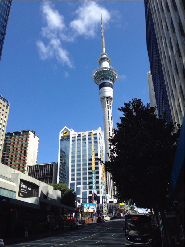 I've arrived in Auckland and spent a couple of days swinging my body clock in to some kind of shape! I remember so little of the last time it's been nice to get to know the place again. 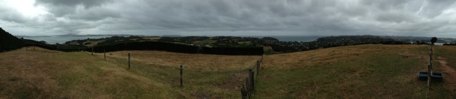 Earlier I took the ferry out to Waikeke, a stunning island of bays and beaches about 40 minutes from the city centre. I set off for a 10k ish walk about. All very pretty although it was quite grey. The heat and humidity was hard work though. What's more the noise in the forest was incredible. The high pitch tsssss of crickets and other insects was almost enough to give me tinnitus! It definitely helped remind me I was somewhere far away from home! This is the route I took It's true to say that I have defaulted to travel mode and am haunting the take aways - I do hate eating alone! It's amazing the difference UK rules on how much salt should be in things have made! I find eating fries almost impossible here - they have so much on them. But I love fries! Argh! I wonder if it really is improving our health - it's certainly affected the flavour. It will be interesting to see if the sugar police will be able to do the same!
Location:Auckland Central,New Zealand
Labels: New Zealand, World Tour MotionX-GPS Track: Church Bay to Blackpool Beach (NZ)
 Phil Mercer uses MotionX-GPS on the iPhone and is sharing with you the following track:
MotionX-GPS Commonly Asked Questions
Please contact MotionX customer support with any comments or questions. All the best, The MotionX Team
US and Foreign Patents Granted and Pending. Fullpower® is a registered trademark of Fullpower Technologies, Inc. MotionX™ is a trademark of Fullpower Technologies, Inc. © Copyright 2003 - 2012 Fullpower Technologies, Inc. All rights reserved.
ver: ; ref-id:
Labels: New Zealand, Walk, World Tour Sunday, February 16, 2014Pilgrim
It's not often that I get a gig quite like this.
(
0
) comments
My friend Helen-Ann is about to become the Bishop of Waikato (that's in New Zealand). It's rather surreal. It never occured to me that in my life I would get to know people with proper responsibilty but I suppose I'd never really thought what being a grown up might entail! So originally I'd tried to work out if I could get to New Zealand for HA's big day... but as usual the finances didn't line up. So I'd resigned myself to not getting that far and planned for other things. Nico popped up with the option of a trip with him to San Francisco, so I jumped at the chance. In the meantime my boss spotted my official invite to HA's consecration and - blow me over - he said that it might be possible to get me to it! After a couple of weeks of tooing and froing (are they real words?) the big boss said yes and I began to reorganise my life. I added in a couple of other NZ based stories that I could cover while here, including the annivesary of the Christchurch earthquake. The plan, a bit of a tour. I was already going to SFO so would continue on from there. And as it was cheaper I could come back a different way. So the plan. San Francisco. Auckland, Hamilton, Christchurch then on to Melbourne and Hong Kong to see Darren and Gareth. First stop. San Francisco.  This time round I corrected that! Nico knows the place really well... so he took me on a pilgrimage. We paid homage to the Castro and I even had a chance to walk up the steps of Barbary Lane. It is amazing how at home I feel here. I realise I'm on holiday, so coming at it from a relaxed point of view. But I loved the friendly people. The bars, the views, the whole atmosphere. The visible poverty and homeless problem is so in your face, but even that didn't really change things. (On second reading that last statement feels a rather callous, but not sure how else I'd cope if I took everything like that personally!) Could it be I've found kind of a spiritual home? I realise 4 days is rather too short to tell... I think I will try and come back. Just to be sure! Labels: USA, World Tour MotionX-GPS Track: Barbary Lane, San Francisco
 Phil Mercer uses MotionX-GPS on the iPhone and is sharing with you the following track:
A walk to the mythical home of Mrs Madrigal.
MotionX-GPS Commonly Asked Questions
Please contact MotionX customer support with any comments or questions. All the best, The MotionX Team
US and Foreign Patents Granted and Pending. Fullpower® is a registered trademark of Fullpower Technologies, Inc. MotionX™ is a trademark of Fullpower Technologies, Inc. © Copyright 2003 - 2012 Fullpower Technologies, Inc. All rights reserved.
ver: ; ref-id:
Labels: USA, Walk, World Tour
|
|||||||||||||||||||||||||||||||||||||||||||||||||||||||||||||||||||||||||||||||||||||||||||||||||||||||||||||||||||||||||||||||||||||||||||||||||||||||||||||||||||||||||||||||||||||||||||||||||||||||||||||||||||||||||||||||||||||||||||||||||||||||||||||||||||||||||||||||||||||||||||||||||||||||||||||||||||||||||||||||||||||||||||||||||||||||||||||||||||||||||||||||||||||||||||||||||||||||||||||||||||||||||||||||||||||||||||||||||||||||||||||||||||||||||||||||||||||||||


